GT12
Grand Tour Valdelsa Valdicecina: a journey through the centuries
Rating
8.3
300Km
Difficult
ENG
OpenRunner ID:
17133066
Start
Poggibonsi
Finish
Poggibonsi
Gradient
5217meters
Slope max
12.00%
Surfaces:
Asphalt
Bicycle type
Road
Gravel
Turism/Comfort
Rappresentazione dell'Itinerario

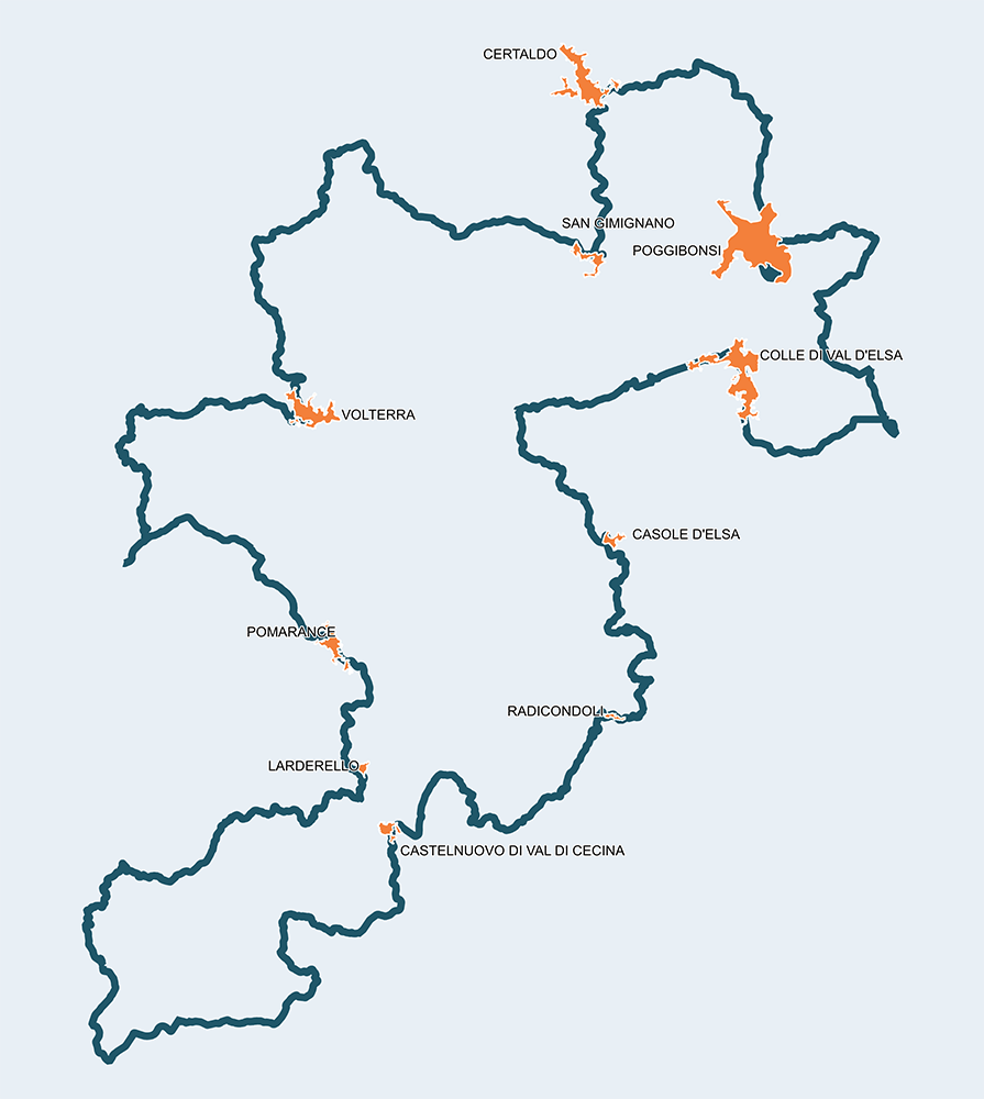
The Grand Tour Valdelsa Valdicecina is the main route of this extraordinary territory, as varied as unique thanks to the presence of many historical testimonies and places to explore, marks of ancient and modern works that highlight a strong identity trait capable of connecting 11 municipalities of two different provinces: Siena and Pisa. The route, on paved roads, is divided into eleven stages, consenting the cyclist, depending on his characteristics and time available, to plan an unforgettable journey of two up to 5-7 days, being able to take advantage of a vast network of services of reception even the most daring or curious and slow explorers.

The km 0 is situated in Poggibonsi, near the railway station, but you can enter this route at any point of the track. Transgressions and off-course are always possible, including diversions to other routes in this area, as long as you don’t get lost in the beauty of these places.


Loghi di Progetto


Loghi Ambito

Video 360°
Stage
1
Poggibonsi – San Gimignano
Medium
Distance
34.00Km
Height difference
618m+
The Poggibonsi Station is the most important intermodal point of the Grand Tour and allows you to leave the traffic of the centre of Val d'Elsa and enter the Sant’Appiano road in just 3 km, heading towards Petrognano and then Semiforte, an ancient fortified city destroyed in 1202 by Florentines, and where you can find, immersed in vineyards and olive trees, the suggestive chapel of San Michele Arcangelo. Following the route, you reach Certaldo, Boccaccio’s city, that could deserve a detour. From Badia a Elmi, you go up to see San Gimignano, stage point and a medieval jewel of UNESCO heritage. Right in this “Medieval Manhattan”, after just 34 kilometers, all the services worthy of a city destination for tourists from all over the world are available. The stage offers a typical uphill route on Tuscan hills of medium difficulty.
Stage
2
San Gimignano – Volterra
Demanding
Distance
39.50Km
(73.50Km/tot.)
Height difference
833m+
(1451.00m+/tot.)
From San Gimignano, the road keeps going up, giving stunning panoramic views on the city and the nearby countryside. You climb a total of 542 meters past the locality of Il Castagno and you reach the Convent of San Vivaldo at the 11 kilometer of the stage, where 20 chapels make up the Sacred Mount of "Tuscany Jerusalem". You descend until reaching Molino dell’Era, meeting the towns of Lano and Villamagna, and then climb towards the land of cliffs, soon arriving to the Etruscan walls of the city of Volterra, deserving of a long stop in order to fully enjoy its historical beauties and its characteristic and hidden spots. The stage is quite demanding, with stretches where slopes reach double-digits.
Stage
3
Volterra – Montecatini Val di Cecina
Easy
Distance
14.50Km
(88.00Km/tot.)
Height difference
297m+
(1748.00m+/tot.)
Short and easy stage lacking particular difficulties, even if in the last stretch you will have to face the climb that leads to Montecatini Val di Cecina, the “Castrum Montis Leonis” situated in the heart of the Metallifere hills and, since Etruscan times, the most important mining site for copper extraction in Europe. You can see the sea from the top of the Tower of Belforti, but also the road you have left, which will grant great surprises.
Stage
4
Montecatini Val di Cecina – Pomarance
Easy
Distance
25.50Km
(113.50Km/tot.)
Height difference
337m+
(2075.00m+/tot.)
Another easy stop that could mark the end of the day for those who have chosen to plan the trip into three days and spend the night in Pomarance. Following the route towards Ponteginori, an industrial village known for its particular architecture. A train station where 4 trains per day wait for the travelers in Ponteginori, including cyclists, to reach the sea of Cecina in just 30 minutes. Pomarance is reached by gently climbing for 8 kilometers. We are in the capital of the largest geothermal area in continental Europe and at the center of natural and cultural beauties of great value. Fumaroles, lakes, geysers, castles and churches risk making your stay longer than expected, but if this happens, no one will ever regret it.
Stage
5
Pomarance – Monteverdi Marittimo
Medium
Distance
34.30Km
(147.70Km/tot.)
Height difference
565m+
(2640.00m+/tot.)
The stage that leads from Pomarance to Monteverdi Marittimo is not among the most difficult since all of its climbs are all viable. The first part is a constant meeting with geothermal energy: in fact in Larderello, located in the center of the "Devil Valley" (so called because of the presence of numerous geysers, which is said to have inspired Dante Alighieri’s Inferno) where 10% of the world’s geothermal energy is produced. Around km 28 of the stage you can admire the village of Canneto, surrounded by fortified walls. Woods and a dense Mediterranean vegetation anticipate your arrival in Monteverdi Marittimo, capital of a territory of great natural beauty marked by the Monterufoli-Caselli Nature Reserve where, you can still meet a small dark horse breed, symbol of the area, the "Cavallino di Monterufoli", in a wild state.
Stage
6
Monteverdi Marittimo – Castelnuovo Val di Cecina
Demanding
Distance
40.70Km
(188.40Km/tot.)
Height difference
920m+
(3560.00m+/tot.)
Challenging stage that, in Castelnuovo Val di Cecina, can mark the end of the second day of travel for those who choose the three days by bike to cover all the Grand Tour. The first 20 kilometers are still easy but from the Frassine crossroad you start to climb, with double digit slopes, to get to Monterotondo Marittimo, then continue for another 18 kilometers and reach 680 meters of altitude near Poggio alle Travi, between Sasso Pisano and Castelnuovo Val di Cecina. In Sasso Pisano, bathing in the warm and healthy thermal waters collected in two small pools could be a unique experience: the "terme libere". Those who are not satisfied to walk in the streets of the village of Castelnuovo Val di Cecina could explore the surroundings to discover the putizze (cold fumes) or the hotter fumaroles. Definitely a Dantesco landscape: Hell or Purgatory? Perhaps an unexpected Paradise.
Stage
7
Castelnuovo Val di Cecina – Radicondoli
Medium
Distance
23.20Km
(216.60Km/tot.)
Height difference
465m+
(4025.00m+/tot.)
The return from the geothermal area to the most gentle and typical hills is marked by the stage that leads to Radicondoli, where geothermal energy starts mixing with the hilly characteristic of the Sienese territory. You climb and descend as in the best traditions of Tuscany, but the most challenging stretch is the last 5 kilometers leading to Radicondoli, an authentic, ancient and lively village immersed in the nature of the Natural Reserve of Cornate and Fosini. The Reserve is an excellent place for night observation of the sky and stars. Before Radicondoli, if you have time, a curious detour to visit the hidden village of Anqua could be a good idea. The Reserve is an excellent place for night sky and stargazing. Before Radicondoli, if you have time, a curious detour to visit the hidden village of Anqua could be a good idea.
Stage
8
Radicondoli – Casole d’Elsa
Easy
Distance
16.60Km
(231.20Km/tot.)
Height difference
320m+
(4345.00m+/tot.)
From Radicondoli to Casole d'Elsa you enter the heart of the Val d'Elsa and soon meet Mensano, a medieval village in the shape of a crescent moon. Longly disputed between Sienese and Florentines, it represents a beautiful panoramic terrace with views of the Metallifere Hills and the Montagnola Senese. The stage is short and mostly easy, with some stretches to overcome with due calm. Casole, an ancient Etruscan village and the Orange Flag of the Touring Club, is seen in all its refined hospitality, including the one of cyclists, recognized as an important cycling destination with "Terre di Casole bike hub".
Stage
9
Casole d’Elsa – Colle di Val d’Elsa
Easy
Distance
23.00Km
(254.20Km/tot.)
Height difference
278m+
(4623.00m+/tot.)
Another easy stage leading from Casole to Colle di Val d'Elsa, the ancient and lively capital of crystal. You start with a stop in the village of Il Merlo and then Montemiccioli, an ancient medieval center with its imposing tower, located right on the border of the two provinces of Pisa and Siena. The Statale road n°68 of Val di Cecina leads to Castel San Gimignano and finally to Campiglia, with a beautiful panoramic view. Colle Alta is reached from Porta Vecchia where this stage ends, but if you want you can continue to Piazza Arnolfo, located in Colle Bassa, where you will find a second Bike Point. With this, through narrow medieval streets, you can better admire the artistic treasures and shops of the city of Arnolfo di Cambio.
Stage
10
Colle di Val d’Elsa – Monteriggioni
Easy
Distance
15.80Km
(270.00Km/tot.)
Height difference
195m+
(4818.00m+/tot.)
Reaching Monteriggioni from Colle di Val d'Elsa is even easier than the previous stage, although the first part of the route winds through the busy urban section that crosses the populous fraction of Gracciano. For those who want to forget the annoying noises of engines, we recommend a dive in the clear waters and waterfalls of the Elsa River Park. Refreshed and regenerated, you arrive at the bridge of Santa Giulia and turn towards Strove and Abbadia a Isola, favourite place of many walkers along the Via Francigena. The Leopoldina Column, the few houses along the road and the municipal building anticipate the Monteriggioni Castle, a unique place with its iconic walls fortified with 14 stone towers, placed high on top of a hill to climb with due calm.
Stage
11
Monteriggioni – Poggibonsi
Medium
Distance
30.00Km
(300.00Km/tot.)
Height difference
399m+
(5217.00m+/tot.)
To get to Poggibonsi the route offers plenty appropriate detours from the main roads, allowing you to use the bike path that leads to Castellina Scalo, get to know with the massive Rocca di Staggia Senese and stray towards the Chianti vineyards to meet a new version of the industrious city of Valdelsa, the one of agricultural products of value, Chianti wine and oil. The names of the towns that meet are therefore Lecchi, Poggio Villore, Gaggiano, Cedda, down to the city and up on the hill where the origins of Poggibonsi were laid: Poggio Imperiale today it is the object of important archaeological research and theater of the Archeodromo, the first and only open-air museum dedicated to the High Middle Ages. It is considered a real unexpected gem that deserves to be seen before returning to the Bike Point of the station to retrace, with your mind, the beauty encountered and the emotions experienced in a unique journey through millennia of history and traditions not erased by time.
Poggibonsi
Badia a Elmi
San Gimignano
Villamagna
Molino d'Era
Volterra
Montecatini Val di Cecina
Ponteginori
Pomarance
Montecerboli
Larderello
Serranzano
Canneto
Monteverdi Marittimo
Sasso Pisano
Castelnuovo Val di Cecina
Anqua
Radicondoli
Mensano
Casole d'Elsa
Il Merlo
Montemiccioli
Castel San Gimignano
Le Grazie
Colle di Val d'Elsa - Bassa
Gracciano - Le Caldane
Strove
Abbadia Isola
Monteriggioni
Colonna di Monteriggioni
Castellina Scalo
Staggia Senese
Lecchi
Poggibonsi
Poggibonsi Fortezza