EV5v
Via Francigena - variante Amiata: a climb through the woods in search of the ancient fortresses and the Abbey of San Salvatore
49Km
Demanding
ENG
OpenRunner ID:
20950580
Start
Bagno Vignoni
Finish
Ponte a Rigo
Gradient
1244meters
Slope max
17.00%
Surfaces:
Asphalt
Gravel
Dirt/offroad
Bicycle type
Gravel
MTB
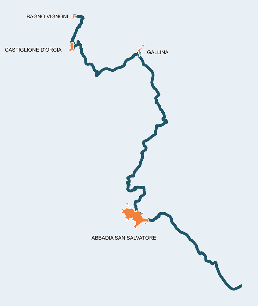
Via Francigena – variante Amiata

As many other routes, the path of Francigena often finds alternatives to the main road. Each one of these has its own historical foundation and certainly does not constitute a solution of minor interest. It's quite obvious that pilgrims found more appealing to follow different paths for various reasons, both of commercial and spiritual nature, or maybe to find an escape, like in our case, from Ghino di Tacco that, from the height of the imposing Rocca di Radicofani, used to control the territory below.

The alternative path offers an interesting journey to reach the abbey of Abbadia San Salvatore, built before the year one thousand. This religious complex used to be a huge spiritual and temporal influence, and a destination for pilgrims travelling towards Rome. These 50km allow cyclists to experience a suggestive dive into the past by discovering ancient fortresses, solitary churches and mystical attractions, such as the cave of San Filippo, which can be reached from Pietrineri by following the Bollore path, a route that leads to a famous thermal area.

It is advised to face this route with a gravel or MTB bike and not to underestimate it for its brevity, since it presents a significant difference in altitude. The maximum height is reached at 918 metres in km 28, after facing sections with double-digit slopes. After about 15 kilometers of scenic descent, the route of the Via Francigena is met again in Ponte a Rigo, a stopping point described by Sigeric in his 990 travel diary returning from Rome.


Itinerario e Tappe

GPX track
Stage
1
Bagno Vignoni – Castiglione d’Orcia
Demanding
Distance
4.50Km
Height difference
270m+
From the Loggiato di Santa Caterina, overlooking the large thermal pool of Bagno Vignoni, we enter the SS 2 Cassia road, until reaching the SP 23 leading to Castiglione d'Orcia. The Rocca di Tentennano situated here appears majestic and could be worth a detour. In any case, we soon arrive at the historic center of Castiglione d'Orcia, a strategic location on the Via Francigena. The Rocca Aldobrandesca stands out above the picturesque town and, a few steps from the old town hall in Piazza del Vecchietta, is the evocative Pieve dei Santi Stefano e Degna. The Point is located inside the quiet municipal gardens, where a rejuvenating stop is recommended.
Stage
2
Castiglione d’Orcia - Gallina
Easy
Distance
9.60Km
(14.10Km/tot.)
Height difference
100m+
(370.00m+/tot.)
The journey to reach the 43rd parallel, located in the center of the rural town of Gallina, is easy and enjoyable for those who love a dirt road and the solitude of the fields. Here, the hills characterize a landscape marked by the distant presence of a large prehistoric sea. The village of Gallina, originally called Osteria della Scala, is an ancient agricultural village located along the Cassia road, and therefore very popular with pilgrims travelling to Rome. Witnesses of this are the numerous fortified farms and post stations.
Stage
3
Gallina – Abbadia San Salvatore
Difficult
Distance
20.70Km
(38.80Km/tot.)
Height difference
856m+
(1226.00m+/tot.)
As the most difficult, this stage is to be taken with due calm, as in less than 21 km we reach an altitude difference of 856 metres . There are many sections of white road, mostly challenging but very beautiful and safe. For those who love climbing, there is no shortage of double-digit slopes. For those seeking transgression, we propose to make a small detour towards the Briccole after leaving Gallina, where Barbarossa captured the heretic friar Arnaldo da Brescia. The effort is, however, amply rewarded by the silences and views of the Val d'Orcia and by the view of the wooded slopes of Mount Amiata. The trail passes Bagni San Filippo, a thermal town that can be a curious and appropriate detour for a good rest at the foot of the “Balena Bianca”. But, when it comes to transgressions, it is also advisable to take a short detour to get to know the cave of San Filippo before facing the most difficult 3 kilometers that take us to reach a maximum height of 918 meters. The Point of Abbadia San Salvatore is located near the famous pilgrim post station, the Benedictine Abbey of San Salvatore.
Stage
4
Abbadia San Salvatore – Ponte a Rigo
Easy
Distance
14.60Km
(49.40Km/tot.)
Height difference
18m+
(1244.00m+/tot.)
Finally, an easy but no less interesting stage, in which we reach Val di Paglia to rejoin the main route of the Francigena. Suggestive badlands will keep the cyclist company all the way. Near the end, we follow the SS2 Cassia road for a few kilometres before reaching the Point of Ponte a Rigo, not far from the merging of the Senna torrent with the Paglia river.
Bagno Vignoni
Castiglione d'Orcia
Gallina
Abbadia San Salvatore
Ponte a Rigo