GT14
Val d'Orcia Gravel Paesaggio Culturale: a journey to get lost in the beauty of a unique territory
158Km
Difficult
OpenRunner ID:
20793834
Start
San Quirico d’Orcia
Finish
San Quirico d’Orcia
Gradient
3870meters
Slope max
15.00%
Surfaces:
Asphalt
Gravel
Bicycle type
Gravel
MTB
Turism/Comfort
Link alla mappa
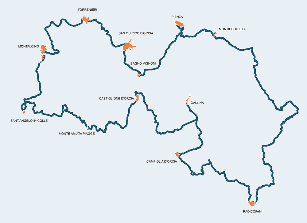
Just like its twin route on paved road, this gravel option of 160km highlights the uniqueness of a territory “kissed by nature and men alike”, recognized by UNESCO as a world heritage site. This route allows one to explore secluded places, to cycle on white roads in great condition and free of motorized traffic. If you have the intention of covering this route in a single day, it is instead advised to pick just two or more stages among the 15 that constitute the entirety of this challenging route. It is also recommended to take a few days to enjoy a slow but curious journey to explore uncontaminated nature, places full of charm and to meet the most friendly people of Val d’Orcia.
Itinerario e Tappe
Stage
1
San Quirico - Torrenieri
Medium
Distance
8.30Km
Height difference
137m+
After leaving the historical centre of San Quirico d’Orcia, Barbarossa's city, you will enter a nice segment of the white road of the Via Francigena towards the Chiesa della Madonna del Riguardo and later take a paved road that runs along the original 1000 Miglia route. The stage is not a challenging one despite the many ups and downs that characterize most parts of the Val d’Orcia. Once in Torrenieri, the Point is located in the space facing the church of Santa Maria Maddalena, adjacent to the Chiesa di San Rocco.
Stage
2
Torrenieri – Montalcino
Demanding
Distance
13.60Km
(21.90Km/tot.)
Height difference
427m+
(564.00m+/tot.)
Climbing Montalcino along the dirt road leading to Val di Cava, and then going up towards the capital of Brunello along the main paved road between expanses of splendid vineyards and historic farms, is an invitation to turn our admiring gaze towards the classic panorama of the Val d'Orcia. In Montalcino, it's best to make a stop to visit the city's many historical attractions or for a tasty taste of a slice of cacio accompanied by honey.
Stage
3
Montalcino – Sant’Angelo in Colle
Medium
Distance
9.30Km
(31.20Km/tot.)
Height difference
135m+
(699.00m+/tot.)
After leaving Montalcino, we go up another 3 kilometers towards Poggio Civitella and the Lume Spento pass at 629 meters above sea level. The road leading to Sant'Angelo in Colle is beautiful, paved and with low motor vehicle traffic. Vineyards and woods lead to the picturesque village of Sant'Angelo in Colle. The Point, located in the public gardens, introduces visitors to the historic center, where the beautiful Romanesque parish church of San Michele Arcangelo stands out. Long under Sienese rule, the town was also a transhumance post station in the past.
Stage
4
Sant’Angelo in Colle – Castelnuovo dell’Abate
Medium
Distance
9.60Km
(40.80Km/tot.)
Height difference
176m+
(875.00m+/tot.)
The dirt road leading to Castelnuovo dell'Abate, already the scene of the Giro d'Italia, winds through woods, vineyards, and farms. Before reaching the town where the Point is located, a secondary road leads us to an extraordinary historical monument, the Abbey of Sant'Antimo, which according to tradition was founded by Charlemagne as a vow to end the plague that was raging in that area. Built in travertine and alabaster, it is certainly a jewel of medieval architecture.
Stage
5
Castelnuovo dell’Abate – Monte Amiata stazione
Easy
Distance
4.70Km
(45.50Km/tot.)
Height difference
21m+
(896.00m+/tot.)
A short and easy stage that ends at the Point situated by an historic railway station near the Orcia River: the ancient Monte Amiata railway station - in the Monte Amiata Scalo area - is today one of the transit points of the Treno Natura.
Stage
6
Monte Amiata stazione – Castiglion d’Orcia
Demanding
Distance
11.30Km
(56.60Km/tot.)
Height difference
495m+
(1391.00m+/tot.)
This is where things start to get more challenging, having to reach the Point situated in Castiglione d'Orcia. At km 48.5, we leave the paved road and take a beautiful white road called Cecchivecchi - l'Aiole. The latter is about 5 kilometers long and very interesting from a naturalistic and landscape point of view. Once in Castiglione d'Orcia, there are many things to see, and among them, it's recommended to search for one of the hidden treasures of the Val d'Orcia, located in the Sala d’Arte San Giovanni, which houses the five faces of the Madonna, created by masters such as Pietro Lorenzetti, Simone Martini, Giovanni di Paolo, and Vecchietta.
Stage
7
Castiglion d’Orcia – Rocca d’Orcia
Easy
Distance
1.40Km
(58.00Km/tot.)
Height difference
8m+
(1399.00m+/tot.)
It’s a small step from Castiglione d'Orcia to Rocca d'Orcia. Taking a walk allows us to experience history with a visit to the majestic Rocca di Tentennano, the medieval streets and the churches of the picturesque village of Rocca d'Orcia. Legend says that Saint Catherine of Siena, on a political and religious mission, was called to the Rocca di Tentennano to pacify the two branches of the Sienese Salimbeni family: here she miraculously received the gift of writing, so much so that she created her most important work, the "Letters of Divine Providence".
Stage
8
Rocca d’Orcia - Gallina
Medium
Distance
14.10Km
(72.20Km/tot.)
Height difference
182m+
(1581.00m+/tot.)
As an alternative to the paved road, beautiful white roads take us all the way to Gallina. Whatever the choice, and in this case it is not the shortest, it means leaving the Pozzo-Gallina municipal road after a few kilometers and taking the Pozzo local road towards Tavoleto. In all cases, we immerse ourselves in the truly iconic countryside of the Val d'Orcia, a miraculous balance between nature and man's skillful work. Along many lonely streets, we come across many farms heralded by cypress trees and cottages transformed into welcoming farmhouses. The route is easy, so it would be a mistake to rush. Gallina, formerly known as Osteria della Scala, keeps its character as a peasant village where you can stop to eat cheese and drink good wine. After all, we are at the 43° parallel of latitude and making a stop is a must.
Stage
9
Gallina – Campiglia d’Orcia
Demanding
Distance
9.70Km
(81.90Km/tot.)
Height difference
447m+
(2028.00m+/tot.)
The Cassia road marks the territory at the bottom of the valley and must be covered for a little over 2 kilometres, up to km 74. Then, we start climbing by taking a path of the Via Francigena towards Podere Sant'Achille and reach an altitude of 750 metres, from where the ancient town of Campiglia d'Orcia dominates the entire surrounding valley. The views are very suggestive and, in autumn, chestnuts are of absolute tastiness.
Stage
10
Campiglia d’Orcia – Bagni San Filippo
Easy
Distance
5.30Km
(87.20Km/tot.)
Height difference
47m+
(2075.00m+/tot.)
Descending from Campiglia d'Orcia along a lonely road surrounded by thick forests is pure joy. The Campiglia-San Filippo is a road of pure poetry that, past the village of Pietrineri, allows us to visit the Cave of the Hermitage of San Filippo Benizi, the religious man who, in an act of great humility, escaped in Val d'Orcia in order not to be named Pope. Legend says that the saint, by hitting a rock with his staff, caused the miraculous birth of the thermal springs that make the nearby Bagni San Filippo one of the most sought-after thermal destinations.
Stage
11
Bagni San Filippo - Radicofani
Demanding
Distance
11.40Km
(98.60Km/tot.)
Height difference
404m+
(2479.00m+/tot.)
From Bagni San Filippo we descend to the Bisarca and, after crossing the Cassia state road, we climb up again to reach the 812 metres of Radicofani, the town of the gentleman bandit Ghino di Tacco. The climb is challenging but spectacular due to the landscape of gullies and grazing meadows. On summer days, the sun hits hard, therefore it is advisable to stock up on a good supply of water and exercise greater caution. Keep in mind that we are climbing an ancient volcano and some lava traces are always visible once we reach the town of Radicofani. The latter is one of the most important and well-equipped villages for the passage of pilgrims on the Francigena and offers a large number of opportunities for a restful stop, which is highly recommended due to the presence of valuable historical testimonies and the esoteric Bosco Isabella with its unmistakable pyramid.
Stage
12
Radicofani - Monticchiello
Difficult
Distance
36.30Km
(134.90Km/tot.)
Height difference
864m+
(3343.00m+/tot.)
This is the most difficult stage of the entire route: in just 36 kilometers we have to face 864 meters of elevation gain, tempered by the fact that we are completely immersed in pure beauty. The first part of the journey is still easy until we reach SP 126, a white road that is very beautiful although challenging. We reach the charming village of Castiglioncello del Trinoro, once called Castiglione dei Ladri and today, conveniently freed from this name, it is considered an iconic destination and a true terrace overlooking the Val d'Orcia. The Foce Pass can be reached by taking a charming dirt road. A must-see at the Foce is a visit to the "Garden of the Val d'Orcia" with a beautiful wisteria pergola, a rose garden, and a spectacular travertine staircase (admission is subject to a fee; we recommend checking the opening days in advance). To finish the stage all that remains is to reach Monticchiello, the characteristic town of the "Teatro Povero". Beauty reigns supreme.
Stage
13
Monticchiello - Pienza
Medium
Distance
8.40Km
(143.30Km/tot.)
Height difference
220m+
(3563.00m+/tot.)
Pienza, the “ideal city” wanted by Enea Silvio Piccolomini, who later became Pope Pius II, is reached after a more leisurely ride, following a beautiful dirt road that, at km 143, enters the Provincial Road of Monte Amiata. Pienza, born “from a thought of love and a dream of beauty,” as Pascoli wrote, deserves a long stop to experience its Renaissance beauty and uniqueness: the cathedral, Palazzo Piccolomini, the Town Hall, Palazzo Borgia, and its entire urban structure will flood the eyes with wonder and amazement.
Stage
14
Pienza – Bagno Vignoni
Easy
Distance
10.10Km
(153.40Km/tot.)
Height difference
88m+
(3651.00m+/tot.)
Another beautiful white road takes us towards Acqua Puzzola, until we come across the SP 53, which leads to the SS2 Cassia and then to the extraordinary village of Bagno Vignoni with its charming "water square", the loggia of Santa Caterina, the ancient mills and its thermal baths. If it weren't for the effort of having to reach San Quirico d'Orcia, a village of equal beauty, one could stay for a long time without any regret.
Stage
15
Bagno Vignoni – San Quirico d’Orcia
Demanding
Distance
5.20Km
(158.60Km/tot.)
Height difference
219m+
(3870.00m+/tot.)
Reaching San Quirico d'Orcia is just a bit of a struggle, as the most likely option is to take a path of the fascinating Via Francigena, pass Vignoni, and continue towards the village. The town of Barbarossa offers everything one might need to brighten the eyes and palate, and satisfy the cyclist with a journey of great charm. From the Collegiata dei Santi Quirico e Giulitta, to the Horti Leonini, to Palazzo Chigi, to the hidden corners of an authentic historic center, all is enjoyable and even deserved for those who have cycled for so long.
San Quirico d'Orcia
Torrenieri
Montalcino
Sant’Angelo in Colle
Castelnuovo dell’Abate
Monte Amiata stazione
Castiglion d’Orcia
Rocca d’Orcia
Gallina
Campiglia d’Orcia
Bagni San Filippo
Radicofani
Monticchiello
Pienza
Bagno Vignoni
San Quirico d'Orcia