CDP
Ciclabile della Pesa e dintorni
42Km
Medium
ENG
OpenRunner ID:
18452034
Start
Cerbaia
Finish
Radda in Chianti
Gradient
704meters
Slope max
15.00%
Surfaces:
Asphalt
Gravel
Dirt/offroad
Bicycle type
Gravel
MTB

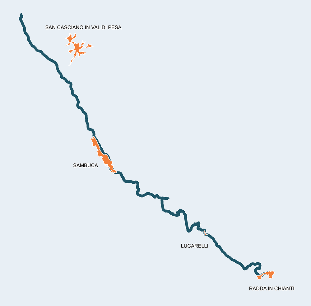
The Ciclabile della Pesa, still not entirely built but still accessible in some traits, was born from the “Contratto di fiume” signed by municipalities, institutions, associations, companies and citizens for the redevelopment and valorization of the river territory of the Pesa, though a combination of shared actions and projects respectful of environmental and landscape values. The partnership with the Consorzio di Bonifica della Toscana Centrale has made the realization of this track possible, and is now useful for reclamation but also outdoor activities. 

When completed, this track will be 54km long from the Molino of San Cassiano of Radda, to the confluence in the Arno river in Montelupo Fiorentino. The current draft allows to follow the first trait, easy after Cerbaia and, through paths and ordinary roads, reach Radda in Chianti. The elevation gain is of 704m in 42km, especially concentrated in this last part since the route from Radda to Cerbaia is mostly downhill.

Loghi Progetto

Loghi Ambito Chianti

Stage
1
Cerbaia – Ponte di Rignana (ciclopedonale)
Easy
Distance
23.90Km
Height difference
184m+
The first section of this route of almost 24 km is easy and can be followed smoothly. You enter the cycle path in Cerbaia, but can also choose to reach Ponte Rotto from San Casciano Val di Pesa from Via Borromeo (SP93). After less than 6 km you will find Parco La Botte, a beautiful park and resting area along the river Pesa. The ease of the route and the proximity might suggest a detour of a few kilometers in the direction of La Collina to visit the famous Etruscan tomb of the Arciere, dating back to the sixth century BC. Following the path, you will reach the Bargino waterfall and the lake of Mulinvecchio. The village of Sambuca anticipates a beautiful stretch along woods and fields until the POINT of Ponte di Rignana where it ends, or begins depending on the direction of the cycle path.
Stage
2
Ponte di Rignana – Radda in Chianti
Difficult
Distance
17.80Km
(41.70Km/tot.)
Height difference
520m+
(704.00m+/tot.)
The cycle path from Ponte di Rignana to San Cassiano is not entirely there, but is still being planned. The stretch proposed is therefore made of paths, white and paved secondary roads, and allows to reach the place where a stone block in the shape of a pyramid is placed, in honor of Nello Mori, shot by German soldiers during the last world war. The first section leading to Sicelle is in reality very demanding, but consents to dive into forests until reaching La Piazza and then Lucarelli. In these small, ancient villages every stop is legit, even if just to refresh. Then, you follow along the river, taking the SP2bis road. Someone, in times quite close to ours, spread the word that along the Pesa river gold nuggets could be found. For some time, the valley has been scouted by diggers who, at most, had the fortune to breathe good air. For this, the valley is called by cyclists "Gold Valley". Once you reach the planned start of the future section of the cycle path, it is better to climb up to Radda, even if the slope of 2 km is very demanding. The medieval capital of the Lega del Chianti is worth a visit.
Cerbaia
San Casciano in Val di Pesa
Bargino
Sambuca
Ponte di Rignana
Madonna di Pietracupa
San Donato in Poggio
Sicelle
Lucarelli
Radda in Chianti