22T2
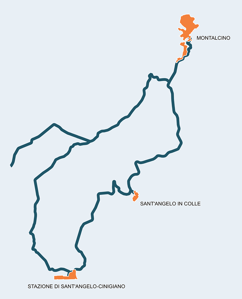
Blaise de Monluc tour: in the refuge of Sienese exiles led by Blaise de Monluc
40Km
Medium
ENG
OpenRunner ID:
20264884
Start
Montalcino
Finish
Montalcino
Gradient
915meters
Slope max
12.00%
Surfaces:
Asphalt
Bicycle type
Gravel
Turism/Comfort
Blaise de Monluc tour

It was 1555 and,in the midst of the war between the Sienese and the Florentines, Siena capitulated, and the exiles took refuge in Montalcino which became the capital of the Republic of Siena. They were led by a French leader, Blaise de Monluc. On one side, the Spanish allies of the Medici and on the other the French of King Henry II, allies of the Sienese. In between, as always, soldiers were sent to die and people starved. For the record, the Spanish won, taking possession of the keys to Montalcino and the treasures of the Val d'Orcia.

The bike excursion that bears the name of this French leader can be easily faced in a single day or, if you like, in a single morning or afternoon. The roads are all paved and mark places that are partly new as they are not affected by celebrated routes such as the Eroica Montalcino. For this reason too, it is worth knowing them.

Itinerario e Tappe

Stage
1
Montalcino – Sant’Angelo in Colle
Medium
Distance
9.30Km
Height difference
132m+
It only takes 3 kilometers to reach the Lume Spento pass from the foot of the imposing Montalcino Fortress, from where we descend surrounded by splendid vineyards, farms and castles. The point located in Sant'Angelo in Colle introduces visitors to this town and its beautiful Romanesque parish church of San Michele Arcangelo. Long under Sienese rule, the town was also known as an important transhumance spot.
Stage
2
Sant’Angelo in Colle – Sant’Angelo Scalo
Easy
Distance
6.80Km
(16.10Km/tot.)
Height difference
17m+
(149.00m+/tot.)
The journey to Sant'Angelo Scalo is even easier, with a beautiful descent that leads downstream to the railway after crossing the vineyards of famous Brunello producing companies. Sant'Angelo Scalo is the last town in Siena that anticipates the Maremma landscapes.
Stage
3
Sant’Angelo Scalo - Camigliano
Medium
Distance
12.50Km
(28.60Km/tot.)
Height difference
299m+
(448.00m+/tot.)
After leaving the Maremma area, we head back north and, past the famous farms of Poggio alle Mura and Argiano, just before the village of Tavernelle, we take the road that leads to Camigliano, a typical village built around an ancient castle. The Pieve dei Santi Biagio e Donato is also a beautiful spot. It is recommended to make a stop before facing the most difficult section of the route.
Stage
4
Camigliano - Montalcino
Demanding
Distance
12.00Km
(40.60Km/tot.)
Height difference
467m+
(915.00m+/tot.)
The provincial 117 is a beautiful and challenging road with slopes reaching double digits. The scenic enchantment that surrounds the cyclist makes us forget the fatigue, disappearing as soon as we reach the Lume Spento pass. Montalcino ("Mons Ilcinus") presents itself in all its beauty. Stopping by the Fortress or at the Palazzo dei Priori or near the Cathedral or the former Bishop's Palace is a good reason to stay late and take advantage of the Montalcino cuisine, well-stocked with Brunello wine. Looking out from one of the panoramic points of the historic center, can inspire unique sights.
Montalcino
Sant’Angelo in Colle
Sant’Angelo Scalo
Camigliano
Montalcino