Here is one of the paths that can not be present in the carnet of every cyclist as very hard but even more beautiful and with a unique charm. Chianti that, tired of its soft hills, allows a mountain excursion is the best example of how much beauty this Tuscan territory can offer. The Monti del Chianti are conquered up to the summit of San Michele, placed at 893m. We find ourselves in a magnificent point of observation of the surrounding landscape, with its Arno, Greve and Pesa valleys. A strategic road node for trade in antiquity but also a relevant military garrison.To reach the end without problems a good workout is necessary, but one can try even if as a first-time, just with much patient and, maybe, a night stay full of silent rest and fine food once reached Villa San Michele.
OpenRunner ID:
17758526
Start
Radda in Chianti
Finish
Radda in Chianti
Gradient
1505meters
Slope max
15.00%
Surfaces:
Asphalt
Dirt/offroad
Bicycle type
Gravel
MTB
Link alla mappa
Stage
1
Radda in Chianti – Villa San Michele
Difficult
Distance
15.80Km
Height difference
624m+
Fairly short but difficult stage. From Radda in Chianti you take a steep and tricky descent because after just 3 kilometers the beautiful climb of Pian d'Albola begins, called this way by cyclists and others. The first 3 kilometers are the hardest ones, but the beauty surrounding this paved road is such that any effort is welcomed. On the right side the massive Albola castle is visible. The road becomes sweeter and even countertrend at the height of the crossroad of Parco Naturale of Cavriglia. You reach the town of Badiaccia a Montemuro for a stop and, before descending to look for the crossroad leading to Villa San Michele, you find Torsoli, another small village known as the “Sun Tower .Both locations have been the scene of numerous armed conflicts in the past due to their strategic location, so much that the original Abbey of San Pietro soon took, also because of its abandonment, the name of Badiaccia. In the villages the ruins of walls and ancient houses are still preserved, immersed in an environment rich in biodiversity. The road you take in the final part of the stage used to be called “Strada di Poggi” since you can see many of them going up the dirt road that leads to the top, to the Point of Villa San Michele, a structure offering the cyclist everything he might need: a well-equipped area, a shop, a tavern and a good bed in a hotel or hostel.
Stage
2
Villa San Michele – Greve in Chianti
Easy
Distance
10.20Km
(26.00Km/tot.)
Height difference
30m+
(654.00m+/tot.)
Monte San Michele, with its 892 meters of altitude, is the highest mountain of Monti del Chianti, and a stop there allows to discover the green heart of Chianti, situated on a high place from which the surrounding valleys are dominated. It is a real pity to start again, but the route must be completed and getting to Greve in Chianti is very easy. The landscape is dominated by a dense wooded area that, only in the vicinity of Greve, leaves space for farms surrounded by vineyards. Halfway though the stage, a small road leads to the detour for the Canonica of Greve in Chianti. You keep following the Melazzano dirt road up to Greve, where the stone porticoes of Piazza Matteotti await the cyclist for a stop between typical shops and fine food.
Stage
3
Greve in Chianti – Radda in Chianti
Difficult
Distance
28.00Km
(54.00Km/tot.)
Height difference
920m+
(1574.00m+/tot.)
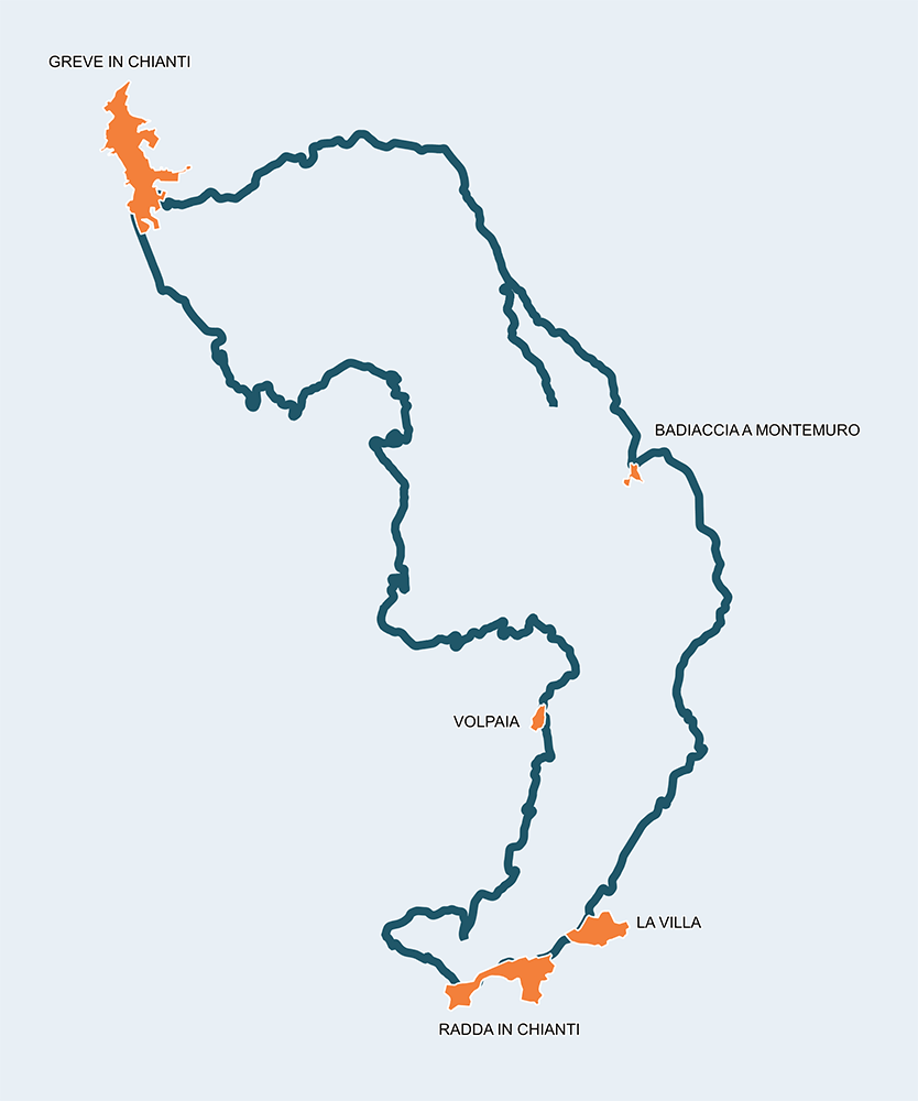
The third and last stage of this trip gets difficult again. After leaving Greve you take the secondary road of Barbiano and deviate towards Via Petriolo, in Lamole’s direction. The road is beautiful, solitary and paved: vineyards, dry stone walls and cypresses accompany the cyclist towards his destination, even if along the path, the chances of taking a detour in one of dirt roads leading to farmhouses and cottages with open cellars are plenty. You enter the “Historical Rural Landscape of Lamole”, where the farmer is also a good architect. After the small church of Casole you get to Lamole, where you can enjoy a meal and a breathtaking view. After leaving Lamole the white road goes up with accessible slopes towards the summit. The vineyards slowly grow distant and the forest comes back to dominate the landscape of this side of Monti del Chianti. After reaching the wooded summit you start descending again and the vineyards come back to delight the view, until reaching the authentic town of Volpaia, still conserving most of its ancient defensive walls and the ruins of a medieval castle. A stop here is mandatory, since drinks and fine food to accompany the rest of the "warrior" are plenty. You descend, accompanied by a landscape matching Lamole’s suggestions, until reaching the SR429 road where you go to look, deceived by the favorable slopes, the SC8 of Campassole that in just 1 km and 300 meters records a good 148 meters of difference in altitude with an average slope of 11%. The place commonly known as “Furnace Creek” is often chosen by sadistic aspirants who, perched up the hill, love to address the cyclist with the Italian saying: "You wanted a bike? Now use it!". It is essential to ignore the provocations and not get caught by the discouragement because Radda is close and, arriving at the top of the slope with just another kilometer, in a climb that almost appears as a descent, you reach the Fiorentina door and then the historical centre. Perhaps a short visit to the fifteenth century wooden crucifix housed in the church of San Niccolò would be appropriate.
Radda in Chianti
La Villa
Badiaccia a Montemuro
Torsoli
Villa San Michele
Greve in Chianti
Lamole
Volpaia