OpenRunner ID:
17033365
Start
Radda in Chianti
Finish
Radda in Chianti
Gradient
661meters
Slope max
13.00%
Surfaces:
Asphalt
Dirt/offroad
Bicycle type
Gravel
MTB
Link alla mappa
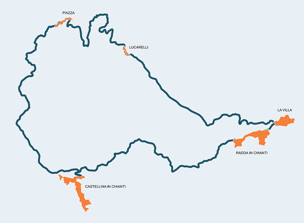
If the twin path, the 5G6, allows one to admire and learn about the Senese landscape and turns south to Radda in Chianti, the present one turns north instead, managing to touch Florence’s lands at the doors of Panzano in Chianti. The core of the journey are still the towns of Radda in Chianti and Castellina in Chianti, with the beauty of their countryside. The kilometers to cover are not many, barely 38, but with an elevation level of 659m caution is required. In this case the protagonists are the vineyards, villas and farms well distributed in a territory of strong personality but, at the same time, gentle and generous like its delicious fruits: wine, olive oil and mushrooms.


Stage
1
Radda in Chianti – Castellina in Chianti
Easy
Distance
10.60Km
Height difference
197m+
The first part of the route up to Castellina in Chianti matches its twin route and consents to reach the Point by following the beautiful SR222, after having a taste of the white road passing through the Parco Archeologico di Poggio alla Croce, only accessible by feet with a path immersing in the deep forest. In Castellina in Chianti it is difficult not to make a stop and take a tour of the historic center where the imposing sixteenth century Rocca stands out.
Stage
2
Castellina in Chianti – Radda in Chianti
Demanding
Distance
27.80Km
(38.40Km/tot.)
Height difference
462m+
(659.00m+/tot.)
From Castellina in Chianti you depart to follow the dirt road of San Martino, not before making a stop at the Tumulo di Montecalvario dating back to the 6th century BC. The Etruscan chariot found next to the four burial chambers is visible at the Museo Archeologico del Chianti in Castellina. After taking the beautiful SP76 road you climb up to an altitude of 624 meters and then descend to the panoramic point placed at the Poggio di Ricavo crossroad where, through deep woods and remote cottages, you reach Nittardi, meeting the wineries and farmhouses anticipating the small village of Piazza, with its San Giorgio church and unmissable tavern. Now you travel along a smooth slope in a beautiful, traffic-free paved road until reaching the Pesa river and take another dirt path, the Sant’Eufrosino road in Panzano in Chianti’s direction. In Fontodi, at the same height of another magnificent panoramic point, you take a paved road (SR222) and stray towards the SP2 road to meet the Pesa river again with a great stop in Lucarelli, a mandatory point for the refreshment of travelers and cyclists. From Lucarelli to the Point placed in Radda in Chianti, you smoothly go up along the “Gold Valley”, named this way for the presence of entire colonies of gold diggers along the river Pesa in the eighties. It is hard to say if they have been as lucky as those, farmers or not, who chose these lands to live in peace with nature.
Radda in Chianti
Castellina in Chianti
Lucarelli
Monterinaldi
La Villa