GT9
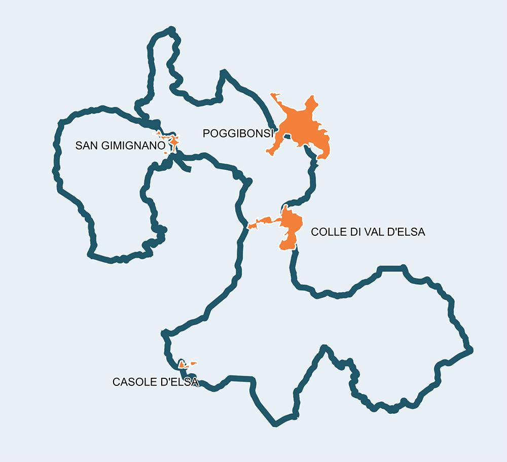
Grand Tour of the Vernaccia: a cultural trip in areas blessed by wine, Francigena and UNESCO
153Km
Demanding
OpenRunner ID:
18234302
Start
San Gimignano
Finish
San Gimignano
Gradient
2512meters
Slope max
12.00%
Surfaces:
Asphalt
Bicycle type
Road
Gravel
Turism/Comfort
Link alla mappa

This route of 150km is named after the well-known wine produced in San Gimignano, a city that, thanks to the beauty of its towers and landmarks, would deserve a lifetime stop.
This is probably the easiest one among all the Tour routes, very relatively since you have to deal with many ups and downs and reach an altitude of 586m in the Montagnola and one of 611m in the Cornocchio.
The roads are paved but mostly secondary, making them so safe they have long been the part of the famous Granfondo della Vernaccia.


Itinerario e Tappe
GPX track
Stage
1
San Gimignano (Santa Lucia) – Casole d’Elsa
Medium
Distance
24.70Km
Height difference
433m+
First short stage starting from the wood of Piemma, in Santa Lucia, where you can enjoy a spectacular view on the city of towers, World Heritage. The arrival is placed in Casole d’Elsa, a well preserved medieval city and an important destination for cyclists thanks to the project “Terre di Casole bike hub”. No particular technical difficulties, if not for a demanding stretch of 200 meters before reaching Casole d’Elsa. You leave Colle di Val d’Elsa in the first half of the stage, and right after you are met with the sight of the Abbey of Santa Maria Assunta a Coneo, worth a pleasant detour.
Stage
2
Casole d’Elsa – Monteriggioni (La Colonna)
Medium
Distance
41.50Km
(66.20Km/tot.)
Height difference
582m+
(1015.00m+/tot.)
The second stage is longer and easy until the 17th kilometer when, from Scorgiano, after meeting Pievescola, the town of mushrooms, a beautiful and challenging slope starts, bringing to the Celsa pass (588 of difference in altitude), placed right after the Marmoraia crossroad. The slopes, in some stretches, reach double digits, but the suggestive Montagnola, rich in parish churches, castles and caves, repays any fatigue. The descent up to the Il Ceppo crossroad offers stunning panoramic views, almost tempting you to make a stop to fully enjoy them. The last part follows the old Cassia road up to the Castle of Monteriggioni, an absolutely unique place with its iconic walls and 14 stone towers. The Point is located at Colonna di Monteriggioni, "port of land", at the feet of the castle that definitely deserves a visit.
Stage
3
Monteriggioni La Colonna – Poggibonsi (Fortezza Poggio Imperiale)
Easy
Distance
18.80Km
(85.00Km/tot.)
Height difference
218m+
(1233.00m+/tot.)
From Monteriggioni to Poggibonsi the road flows smoothly, but be aware of vehicular traffic starting from Gracciano. On the other hand, encounters with art and history are many and of the utmost respect: from Abbadia a Isola, the favourite refuge of Via Francigena pilgrims, to Colle Val d’Elsa, a beautiful city rich in many art treasures and crystal (which gives it the nickname of “Boemia d'Italia”), not to forget the possibility of a refreshing bath in the clear waters of the River Park of Alta Valdelsa. Poggibonsi, lastly, is met in its most interesting part: San Lucchese, the Fortezza di Poggio Imperiale and the extraordinary Archeodrome almost make you forget the industrial profile of this lively town.
Stage
4
Poggibonsi (Fortezza Poggio Imperiale) – San Gimignano (Porta San Matteo)
Medium
Distance
30.20Km
(115.20Km/tot.)
Height difference
514m+
(1747.00m+/tot.)
After leaving the historical part of Poggibonsi and the city’s noise, you take the SP95, a road parallel to the trafficked SR429 and the Elsa river. At the 10th kilometer you detour towards the town of Ulignano and then Sant’Andrea, entering the area where the production of the Vernaccia, a fine white wine DOCG of San Gimignano, happens. The n° 1 provincial road goes up, through vineyards and olive trees, up to San Gimignano, where a suitable stop restores mind and body, having plenty of choice between the things to see or taste, perhaps based on the renowned local saffron.
Stage
5
San Gimignano (Porta San Matteo) – San Gimignano (Santa Lucia)
Demanding
Distance
37.90Km
(153.10Km/tot.)
Height difference
772m+
(2519.00m+/tot.)
This last stage starts from the center of San Gimignano to return to the city of towers, at the Bike Point placed in Villaggio del Pellegrino, in the forest of Piemma, in Santa Lucia. This time hard work will be necessary because the stage requires it, particularly in the stretch leading to Poggio del Cornocchio, located at an altitude 611 meters in the Nature Reserve of Castelvecchio. The SP62 road, leading to Cornocchio, crosses dense woods and pastures with stunning views on the Volterrano and on the Metallifere hills. The SS68 road leads to the tower of Montemiccioli and then to Castel San Gimignano, where you detour in San Donato’s direction, to finally return in San Gimignano without having to abandon the view of the precious vineyards of Vernaccia. In any case, a stop in San Gimignano, hopefully and certainly long, can only be honored by a local excellence such as saffron, as well as a glass of good wine, to enjoy it in a nice rice dish or in the “schiacciata”.
Santa Lucia
San Gimignano
Le Grazie
Quartaia
Casole d'Elsa
Molino d'Elsa
Pievescola
Scorgiano
Colonna di Monteriggioni
Abbadia Isola
Strove
Gracciano
Poggibonsi Fortezza
Ulignano
San Benedetto
San Donato
Castel San Gimignano
San Gimignano