GT8
GGT Gravel Grand Tour: the charm of the dusty roads designed by nature
224Km
Difficult
OpenRunner ID:
10912894
Start
Casole d'Elsa
Finish
Casole d'Elsa
Gradient
4869meters
Slope max
15.00%
Surfaces:
Asphalt
Gravel
Bicycle type
Gravel
MTB
Turism/Comfort
Link alla mappa
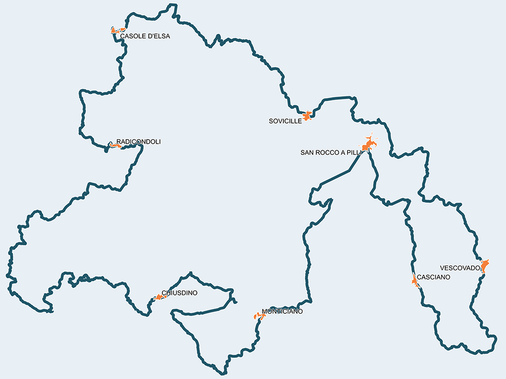
Compared to the twin Grand Tour Val di Merse, the gravel route is distinguished by a greater length, for the starting point of Casole in Val d'Elsa and for a much greater amount of dirt roads and unpaved roads so as to make it very difficult and can be addressed almost exclusively with a gravel bike or MTB.
We recommend doing it over several days and, at a leisurely pace, is convenient from every point of view.
Itinerario e Tappe
GPX track
Stage
1
Casole d'Elsa - Radicondoli
Medium
Distance
18.70Km
Height difference
551m+
From Casole we first pass Mensano and then Monteguidi, from where we can reach Radicondoli, leaving behind the characteristic landscape of the Colline Metallifere. The beginning is the prelude to the great commitment and attention that you will have to put into the journey.
Stage
2
Radicondoli - Chiusdino
Difficult
Distance
55.50Km
(74.20Km/tot.)
Height difference
1554m+
(2105.00m+/tot.)
From Radicondoli to Chiusdino, this is painful for the body but joyful for the mind. The former can be mitigated by the attitude to be held, which must be prudent and curious. The advice, therefore, is to make many stops starting from Belforte, Anqua and Gerfalco, villages so out of time that they can be considered real «land islands». The Cornate pass is at 818 meters with stretches at 16%. The dirt road is a constant, as are the woods and the wild animals. Once past Ciciano, from where you can catch a glimpse of the beautiful Val di Merse, you'll find the panoramic GATE of Chiusdino.
Stage
3
Chiusdino - Monticiano
Easy
Distance
30.10Km
(104.30Km/tot.)
Height difference
425m+
(2530.00m+/tot.)
This is the easiest stage, so to speak, with lots of dirt road. The extraordinary Abbey of San Galgano and the sword in the rock make the stop even more inviting. GATE in Monticiano.
Stage
4
Monticiano - San Rocco a Pilli
Easy
Distance
24.10Km
(128.40Km/tot.)
Height difference
355m+
(2885.00m+/tot.)
From Monticiano you pedal towards the «sea of Brenna» and a bath in the Merse could bring unexpected benefits. Stigliano, with its short supply chain store, is hospitable and anticipates the GATE of San Rocco a Pilli that arrives after the well-known "Vidritta" dirt road.
Stage
5
San Rocco a Pilli - Vescovado
Demanding
Distance
36.00Km
(164.40Km/tot.)
Height difference
760m+
(3645.00m+/tot.)
It's hard to resist the beauty that one encounters going up from Bagnaia, turning to Casciano towards the Basso Merse Natural Reserve and then meeting the Ombrone and the ancient railway with the Befa station and the Mines of Murlo. Unique delights up to the Etruscan POINT.
Stage
6
Vescovado - Sovicille
Medium
Distance
30.90Km
(195.30Km/tot.)
Height difference
508m+
(4153.00m+/tot.)
From the area of Murlo, where the features of the inhabitants are those of the ancient Etruscan people, one travels in the direction of Siena without ever encountering it to deviate at the GATE of Sovicille.
Stage
7
Sovicille - Casole d'Elsa
Demanding
Distance
28.70Km
(224.00Km/tot.)
Height difference
716m+
(4869.00m+/tot.)
From Sovicille, the capital of the municipality with no less than 55 medieval villages, we climb the mysterious Montagnola that hides many treasures to be discovered. The GATE of Casole d'Elsa comes at the end of one of the most beautiful efforts that a cyclist can make in his or her life.
Casole d'Elsa
Mensano
Monteguidi
Radicondoli
Montingegnoli
Anqua
Gerfalco
Travale
Ciciano
Chiusdino
San Galgano
Palazzetto
Monticiano
Stigliano
San Rocco a Pilli
Casciano
La Befa
Murlo
Vescovado
Ville di Corsano
Sovicille
Ancaiano
Casole d'Elsa